GeoApps
Bring your data to life in maps
Organizations have enormous amounts of geographical data, but it often remains hidden in systems. Citizens, policymakers and businesses need accessible maps and dashboards – not opaque spreadsheets.
Why GeoApps?
Publish geodata in minutes, not months
From map viewer to dashboard: one platform for everything
User-friendly for everyone, no GIS expertise required
Scalable from municipality to national level
Bring your data to life in maps
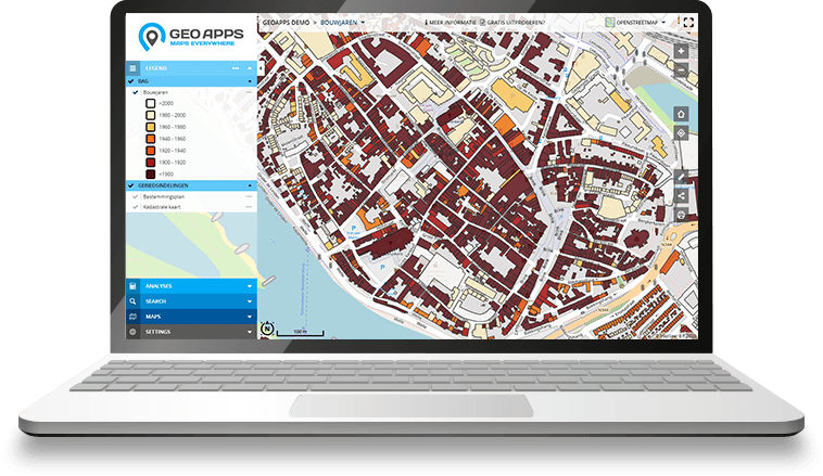
Our innovative GeoApps platform offers all the apps to publish geodata online, as an attractive map viewer, narrative website or interactive dashboard.
GeoApps is user-friendly and fully adaptable to your wishes, both in terms of design and functionality.
GeoApps is also standardly pre-filled with various color templates, style libraries and functionalities. This means every map project can be realized quickly – whether it is a simple map viewer or a complex project with diverse applications and users.
What GeoApps enables for you
Interactive map viewers
Narrative websites
Dynamic dashboards
Customizable templates
User-friendly interface
Extensive API support
Start today with GeoApps
Transform your workflows with powerful Geo-ICT solutions. More than 500 organizations trust MapGear for their geographical information – with GeoApps as one of our solutions. Join satisfied customers worldwide.
Discover our other products
Expand your Geo-ICT toolkit with our complete range of innovative solutions
The interactive participation tool for plans and developments
More about MapTalkThe online portal for your geodata
More about MapServicesThe digital map table for trade fairs, events & workshops
More about TouchTableCurrent insight into sustainable opportunities and climate adaptation
More about DuurzaamheidskaartWant to know more?
Do you have questions and want to know more about one of our products or request a demo? Fill in the contact form so we can get in touch with you.